This is the site where Mason and Dixon recorded the final astronomical observations used to calculate the latitude of their survey line.
PENTRESS — After two years of hacking their way west through the wilds of colonial America in a meticulously calibrated straight line, Charles Mason and Jeremiah Dixon brought their historic survey to an end 2 miles northeast of this Monongalia County community on Oct. 11, 1767.
Here, the Englishmen spent six nights taking astronomical observations to identify the precise location of the western end of their survey. Once their calculations were complete and adjustments to the survey line were made, Mason and Dixon cleared a spot for a monument to mark the end point.
The site was situated “on the top of a very lofty Ridge,” Mason wrote in his journal, “233 miles, 17 chains and 48 links from the post marked West in Mr. [Alexander] Bryan’s Field,” at the survey’s starting point.
On the summit of what is now known as Browns Hill, “we set up a post marked W on the west side and heaped around it Earth and Stone three yards and a half diameter at the Bottom and five feet high, the figure nearly conical,” Mason wrote.
That site is preserved and protected within Mason-Dixon Historical Park, a 295-acre expanse of forest, fields and hills just off W.Va. 7, about 11 miles west of Morgantown and 9 miles east of Blacksville. From the park’s office, a steep, half-mile hike up the M-D Marker Trail brings visitors to site of the survey’s western end point.
Interpretive signs flank the monument marking the westernmost point of the Mason-Dixon Survey, which came to an end here in October 1767. A trail at Mason-Dixon Historical Park in Monongalia County leads visitors to the site.
Those making the hike will not see the makeshift marker left by Mason and Dixon nearly 254 years ago. It was replaced by a stone monument set by C.H. Sinclair of the U.S. Coast and Geodetic Survey in 1883 during a re-survey of the historic line, which Sinclair found to have strayed less than 1.5 inches off the latitude he calculated for this point.
Sinclair’s monument remains in place, its south face displaying the carved letters ‘WV’ indicating the West Virginia side of the line, a ‘P’ denoting Pennsylvania on its north side.
The Mason-Dixon Survey produced “the most important boundary demarcation in Colonial America and what is today the most celebrated boundary line in the United States,” according to the National Register of Historic Places listing for the site.
While Mason and Dixon might have experienced a feeling of exhilaration and a sense of achievement upon reaching this site, relief and disappointment also were likely to have been a part of the emotional mix.
A monument placed in 1883 by C. H. Sinclair of the U.S. Coast and Geodetic Survey marks the westernmost point reached by Charles Mason and Jeremiah Dixon during their historic east-west survey in 1767. The letters “WV” are carved on the south-facing side of the marker to indicate the West Virginia side of its border with Pennsylvania, marked with a “P” on the opposite side of the stone.
They were relieved that their trek across a frontier “uninhabited by anything but wild Indians, bears and rattlesnakes,” as Dixon described it, had come to an end. But they had not fully accomplished their mission, by failing to reach their ultimate goal, which lay 21.65 miles to the west. There, at a point five degrees in longitude west of their survey line’s starting point, was the still uncharted western border of Pennsylvania. That missing link in the Mason-Dixon Line would not be charted for another 17 years.
Mason and Dixon had been able to travel this far west thanks to an agreement with the Six Nations, a confederation of northern tribes, that had been negotiated several months earlier. The agreement called for a party of 14 Mohawk and Onondaga tribesmen to accompany the surveyors, to make sure they did not spark a conflict by crossing into territory claimed by enemies of the Six Nations.
One month prior to arriving here, the survey party began to press hard against that boundary. When it reached the Cheat River, two of the Mohawks accompanying the crew balked at crossing the river and continuing west.
The surveyors brought their trek to a halt and held a council with their entourage of native observers. Mason wrote that an agreement was reached to cross the Cheat and rest for several days on the far shore before cautiously proceeding west.
When the party resumed its journey, a log structure for storing supplies was built on a narrow point of land near the Cheat River’s confluence with the Monongahela River, an area that Mason and Dixon seemed to appreciate.
“In the rivers of Cheat and the Monaungahela,” as Mason spelled the stream, “we found plenty of fish of various sorts, and very large, particularly catfish. Caught a lizard near a foot in length. Coal is found in plenty … and the soil is very rich.”
Upon reaching the Monongahela, 26 of the survey crew’s 40-plus hired brush-cutters, pack-horse wranglers, instrument bearers and cooks refused to continue, and turned back, fearing attack from the Shawnee, among the Six Nations’ foes. Despite the loss of more than half their crew, Mason and Dixon pressed on.
After crossing the Monongahela and after traveling 2 miles west, “we were paid a visit by Catfish [a chief of the Delawares], his nephew and wife,” Mason wrote, observing that “they were very well dressed, nearly like Europeans.”
The survey party’s native delegation explained the purpose of Mason and Dixon’s travel through the area to the Delaware chief, whose tribe was not a part of the Six Nations confederation. Chief Catfish reportedly voiced no opposition to the surveyors’ presence, and traveled with the group for a few miles before parting company.
Soon after their departure, “eight warriors of the Seneca Nation fell in with us and stayed with us two days,” Mason wrote, noting that the Senecas were allied with the Six Nations, which made him “very glad to see them.” The Senecas, who arrived “equipped with blankets and kettles, tomahawks, guns and bows and arrows,” planned to travel south to battle the Cherokee.
On Oct. 8, the survey crew crossed Dunkard Creek, and following its valley westward, crossed the stream two more times in the next two days.
Just past the third crossing, the survey group came upon the Catawba War Path, a north-south trail extending from upstate New York to South Carolina.
Operated my Monongalia County, Mason-Dixon Historical Park straddles the West Virginia-Pennsylvania border between Morgantown and Blacksville.
KENNY KEMP | Gazette-Mail
The heavily traveled footpath marked the western limit of sanctioned travel and relative safety for the Englishmen, the Six Nations representatives told Mason and Dixon. The native group then made it clear they “would not travel one step farther westward,” Mason wrote.
For Mason and Dixon, it was the end of the line.
It was not until the following century that the Mason-Dixon Line came to be regarded as the dividing line between states in which slavery took place and those where it was forbidden.
The survey had been commissioned by the Penn and Calvert families, recipients of vast land grants from England’s King Charles I and King Charles II, around which the colonies of Pennsylvania and Maryland were formed. The boundaries of the land grants were vague and had been in dispute for decades before the two families agreed to hire Mason and Dixon to settle the issue once and for all.
Marker directs visitors to the trail leading to the site of the Mason-Dixon Survey’s westernmost points at Mason-Dixon Historical Park.
KENNY KEMP | Gazette-Mail
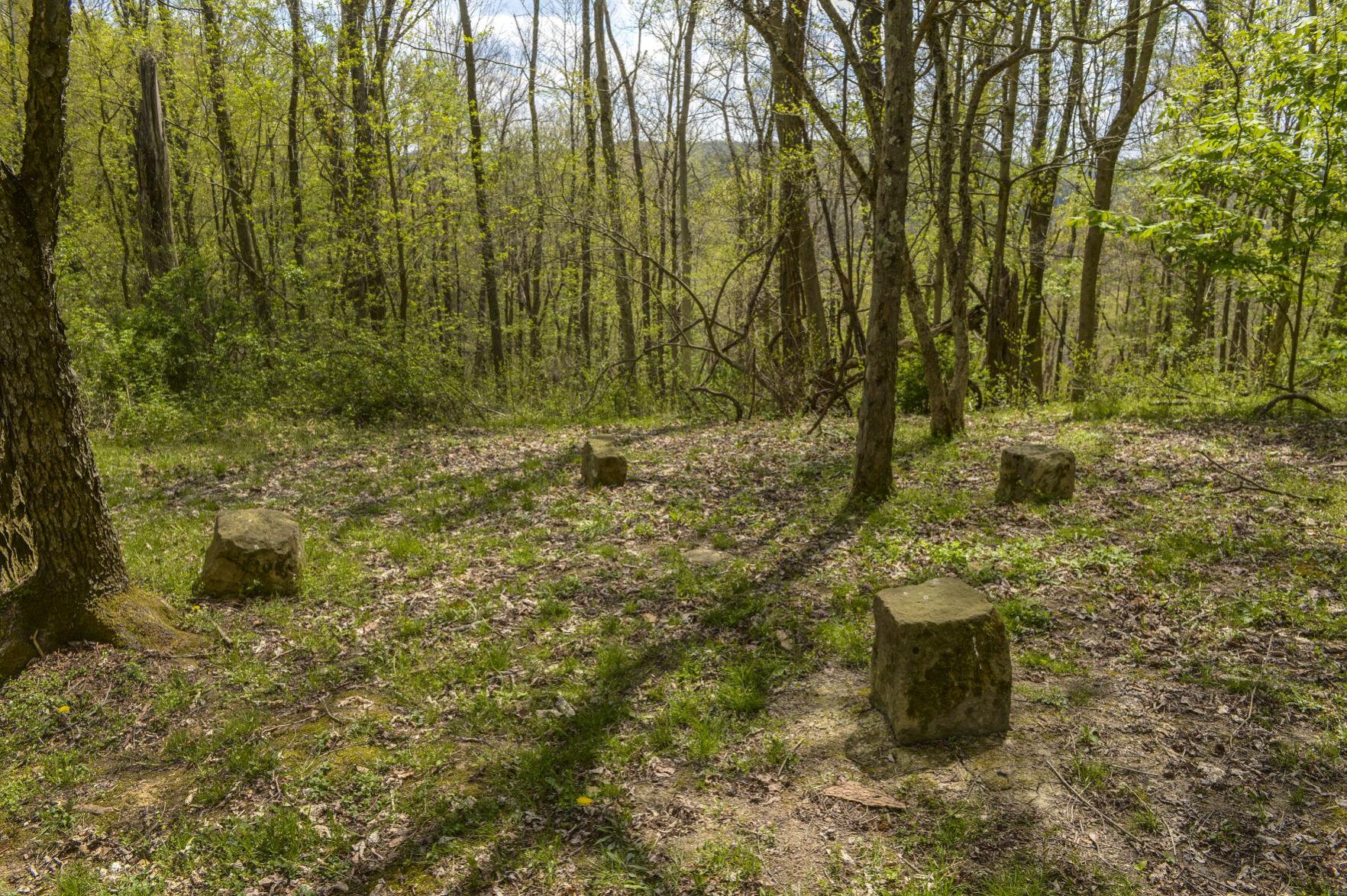
The line Mason and Dixon followed through the wilderness was guided by astronomical observations made using a zenith sector, a 6-foot-tall post topped by a telescope, the most up-to-date and accurate surveying instrument in the world at the time. Each mile along the line was then marked with a pre-cut limestone block shipped from England, with larger “capstone” blocks placed at 5-mile intervals.
The surveyors, both in their 30s, produced results that were accepted by both long-feuding families, and were used to establish Pennsylvania’s border with Maryland, as well as with Virginia — and West Virginia after its statehood in 1863.
In nominating the Mason-Dixon Terminal Point on Browns Hill for its spot on the National Register of Historic Places, Emory Kemp, former civil engineering department head and now professor emeritus at WVU, cited the Englishmen for:
“Their faithfulness and perseverance when faced with extreme adversities such as sub-zero temperatures, rugged topography and imminence of destruction” from the warring native tribes whose land they passed through. Kemp said their accomplishment “is an inspiration to which engineering and science may point with pride.”
At Mason-Dixon Historical Park, the hike up the trail to visit the site “is steep enough to be a little intimidating,” according to J.R. Petsko, its superintendent, “but it draws a fair number of people up there.”
About 60 feet downhill from the monument, through which the Pennsylvania-West Virginia border passes, hikers on the M-D Monument Trail pass a well-marked spot on an almost sheer bluff towering above Deckers Creek where the Englishmen took their survey’s final celestial observations.
The park, which sprawls across the border between Monongalia County, West Virginia, and Greene County, Pennsylvania, also contains the site where the Mason-Dixon party made their third crossing of Dunkard Creek. There, side-by-side benches provide adjacent seating in two states.
The park offers hiking and mountain biking on nine trails, the most popular of which is the Fairy Door Trail, where Morgantown area woodcarvers and other artists have created whimsical domestic scenes involving the small mythical beings behind tiny doors at 27 trailside sites.
Picnic pavilions, three log cabins, and a barn with kitchen and dining facilities are available to rent at the park, which begins a series of outdoor music performances this month. For more information, visit Mason-Dixon Historical Park’s Facebook page or call 304-879-4101.
Reach Rick Steelhammer at
rsteelhammer@wvgazettemail.com,
304-348-5169 or follow @rsteelhammer on Twitter.
URL: